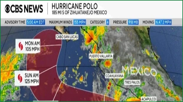
Hurricane Polo, a formidable major hurricane, continues to move off the southwestern coast of Mexico. Although the storm reached extreme intensity earlier this week, meteorologists anticipate that it will skirt the Pacific shoreline over the coming days rather than making a direct landfall. As of early Wednesday, the system was located approximately 185 miles off the coast of Zihuatanejo, a resort city in the state of Guerrero, and was crawling northward at a speed of 2 mph.
The U.S. National Hurricane Center reported that Polo’s maximum sustained winds reached as high as 180 mph on Tuesday. By Wednesday morning, those winds had decreased slightly to 155 mph, positioning the storm just below the 157 mph threshold required for Category 5 status. While forecasters expect the storm's intensity to fluctuate, it is projected to remain a powerful major hurricane for the immediate future.
Outer rain bands from the system have already begun to reach the Mexican coastline. The National Hurricane Center issued stern warnings regarding heavy rainfall, noting that it may trigger life-threatening flooding and mudslides, particularly in areas characterized by steep terrain. From Wednesday through Thursday, parts of Guerrero and Michoacán are expected to receive 3 to 6 inches of rain, with localized totals potentially reaching up to 8 inches. Coastal regions in Oaxaca, Colima, and Jalisco could see between 2 and 4 inches of rainfall during the same period.
The Mexican government has responded by issuing a tropical storm warning for the coastline stretching from Tecpan de Galeana in Guerrero to Punta San Telmo in Michoacán. Additionally, a tropical storm watch is in effect for the area from Punta San Telmo to Playa Perula in Jalisco. Residents in these zones are advised to prepare for tropical storm conditions, which are expected to develop in the warning areas on Wednesday and potentially in the watch areas by Thursday.
Beyond the immediate rainfall, the storm is generating hazardous conditions at sea, including life-threatening surf and rip currents along the southwestern coast. Polo extends hurricane-force winds up to 40 miles from its center, with tropical storm-force winds reaching out 105 miles. While currently positioned far south of the Baja California peninsula, long-term forecasts suggest the storm could shift in that direction early next week. Historically, Polo ranks as the second strongest hurricane in the Eastern Pacific based on central pressure, trailing only Hurricane Patricia from 2015, and is tied for the third strongest in terms of wind speed.