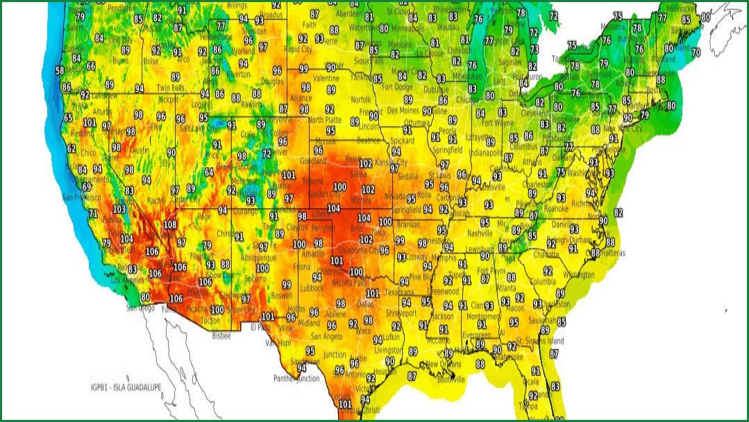
A combination of dangerously high temperatures, parched landscapes, and severe thunderstorms is set to impact much of the United States this week. Meteorologists warn that these conditions will heighten the risk of flash flooding and wildfires across several regions. In the Western United States, including California, Nevada, and Arizona, extreme heat warnings remain in effect through Wednesday, August 12.
Temperatures in these areas have already reached triple digits, with some regions seeing forecasts as high as 114 degrees. The heat, which sweltered states from California to Colorado over the weekend, is expected to persist through midweek and spread east into the central Rockies and Great Plains.
AccuWeather Meteorologist Kai Kerkow noted that the Northwest faces a very high wildfire risk due to the combination of dry vegetation, high heat, and gusty winds. This environment supports both the growth of existing blazes and the ignition of new ones. Areas at particular risk include Washington, Oregon, Idaho, and Wyoming, alongside parts of Kansas, Oklahoma, and Texas. Furthermore, lightning activity in Colorado, Utah, Nevada, and California could trigger additional fire starts.
Persistent poor air quality alerts continue near Spokane, Washington, as existing fires burn, and the incoming storms threaten to exacerbate those issues, according to Kerkow. Additionally, AccuWeather Lead Long-Range Expert Paul Pastelok noted that some wildfire debris will migrate East this week, creating a hazy look to the sky.
While the West contends with fire risks, the Eastern and Central United States are facing a different threat. Humid air is fueling severe thunderstorms capable of producing damaging winds, heavy rainfall, and flash flooding. Through Tuesday, August 11, the National Weather Service warns that storms moving from Northeastern Illinois to Central Pennsylvania and Northern Virginia could significantly disrupt morning and evening commutes in major metropolitan centers like Chicago, Detroit, and Pittsburgh.
Southern Ohio, Eastern Kentucky, West Virginia, and southwestern Pennsylvania are at the greatest risk for flash flooding, with the potential for up to 12 inches of rain, according to AccuWeather meteorologists. Hail and heavy downpours are also possible in the Midwest and Dakotas from Monday, August 10, into Tuesday, August 11.
In the central regions, including Kansas and Missouri, extreme heat warnings are in place until August 12, with heat indices projected to reach up to 107 degrees. Meanwhile, across the Atlantic, Western and Central Europe are preparing for their fifth heat wave of the year.
Countries including France, Spain, and Italy are seeing temperatures exceed 95 degrees Fahrenheit, or 35 degrees Celsius. In the French community of Céret, temperatures reached 40.3 degrees Celsius, or roughly 105 degrees Fahrenheit, on August 8.
From August 12 to August 14, temperatures are expected to soar above 95 degrees Fahrenheit. This intense heat has worsened drought conditions and fueled wildfires in the Bordeaux region of France and parts of central Spain. These conditions will also impact Americans traveling to Europe to see a total solar eclipse passing across the Arctic, Greenland, Iceland, northern Spain, and parts of Portugal on August 12.